
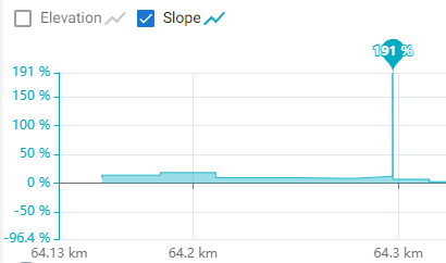
Another silly gradient, track glitch
I hope the Irish road/ EuroVelo1 doesn't have 191% gradient!!
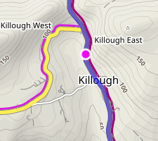
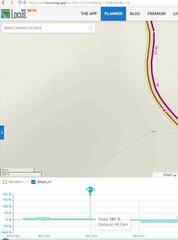
approx. location https://web.locusmap.app/en/?lat=51.615184&lng=-10.067044&z=18
I've reported some of these before, for example 8 months ago here (although only 25% in this older example), so no need to re-describe the underlying issue here. But I had just hoped they were fixed by now. The same track viewed in LM4 with OAM map shows "ordinary" gradient. It makes planning with the web "planner" tedious when it occurs, as the errant point has to be found, fixed in LM4, then sync'd back to the web. I have 3 to fix.
Maybe simpler to plan in LM4 instead?
Two-way sync of the mouse between the chart & map as suggested a long time ago would reduce the tedium too - only 6 votes - not much but a standard feature in RWGPS & BRouter-web for ever.
 The same problem
While trying to remove these annoying track glitches I believe I've found a bug: when exported as a GPX then imported into Garmin BaseCamp, the track point at 64.18km (point #1969) has a leg distance of zero metres! When I deleted this point then imported back into Locus web planner, the glitch was correctly removed.
So does that help you resolve this problem?
No improvement after 16 months, or even a comment! Using the web planner should be more efficient for route planning, but often works out less. Sometimes I sync back to device then "recalculate the elevations" just to fix this up. Tedious & annoying.
sample route: https://link.locusmap.app/t/kyqqhq
I've never seen this before - the elevations are calculated but no line is graphed!!
clearly calculated:
and for this one time the slope is actually "reasonable" except a few silly points near the end, but at least not +/-100%:
PS. after checking a few other planned routes, I think a bug has been recently introduced. The elevation graph is invisible for many existing tracks.
And here is another excellent slope glitch example (485% is quite some steep hill) https://link.locusmap.app/t/gjzbia:
Whole my library all of a sudden lost elevation graph (it is there, just invisible). I work with it every day for about four months (planning Pacific crest trail), I haven't done anything, just playing with zoom to locate various passes and road crossings. No rerouting, nothing. 54days to take off :-(
Whole my library all of a sudden lost elevation graph (it is there, just invisible). I work with it every day for about four months (planning Pacific crest trail), I haven't done anything, just playing with zoom to locate various passes and road crossings. No rerouting, nothing. 54days to take off :-(
The 191% gradient glitch in the Locus Map web planner is a classic elevation data outlier, often caused by a single miscalculated GPS coordinate or a "spike" in the underlying HGT/DEM (Digital Elevation Model) files. When a point is recorded even a few meters off the actual path—perhaps onto a steep cliffside or due to a signal bounce—the software interprets the vertical gain over a tiny horizontal distance as an impossible slope.
The 191% gradient glitch in the Locus Map web planner is a classic elevation data outlier, often caused by a single miscalculated GPS coordinate or a "spike" in the underlying HGT/DEM (Digital Elevation Model) files. When a point is recorded even a few meters off the actual path—perhaps onto a steep cliffside or due to a signal bounce—the software interprets the vertical gain over a tiny horizontal distance as an impossible slope.
Replies have been locked on this page!