
This object is in archive!
Garmin route import display is not correct.
Not a Problem
Please have a look. It seems import > display and export to track of a Garmin route is not optimal correct.
In a Locus export into track: Find 9 original wpt + 15 rtept in the waypointlist.
Direct import into Locus > Map > Expect to see 9 waypoints but Locus shows 24 waypoints !
See picture.
A. by Locus import and than the same picture
B. By using a converted track by the JavawaRTWtool. (pc)
In attachment find the gpx files.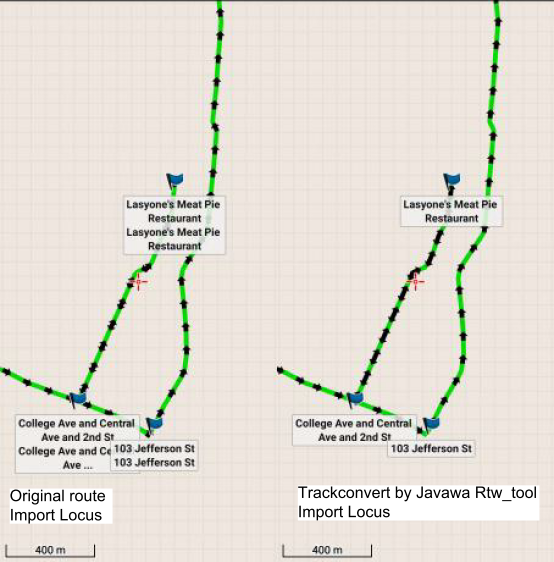
Files:
Day_1_Route_by_...
 The same problem
Not promoting rtept's into wpt's would also solve the "red arrow" problematic of the rte_wpt route import, and correct export into track_wpt. Correct display of Garmin route (gpx 1.1/extension_gpxx) by gpxviewer app was ok.
Not promoting rtept's into wpt's would also solve the "red arrow" problematic of the rte_wpt route import, and correct export into track_wpt. Correct display of Garmin route (gpx 1.1/extension_gpxx) by gpxviewer app was ok.
Good day Willy,
little complicated task. If you just "display" file or use MapItems, in both cases Locus apply "Merge points with the imported track". The result is what you see ... waypoints are attached to track itself.
The behavior you need is possible only with direct import (not display) and with disabled this "merge" option.
Then I see correctly on the map track with its 15 waypoints + 9 separate points. Which is correct, is it? If so, the problem we have here is that the "merge" option is automatically enabled for "display" import, right?
Which is correct, is it?
I do not think so.
Javawa (pc) is my best example reference program. (Designed for best compatibility with Garmin hardware)
Display by Javawa (pc) and gpxviewer app schows the path and the 9 wpt and is ok.
Locus result is nok.
Route(rte) + 9 wpt to trackconvert by Javawa is the correct expected result: track(trk) + 9wpt and is ok.
Locus result is nok.
Rtept's should not be promoted (display) nor converted into wpt's.
I think best compatibility with Garmin is using some Garmin stuff. Do not know why Javawa should be better.
So I tried Garmin basecamp and here is the result.
Route is visible on the map. All 9 waypoints are separately listed in the side panel. 15 attached route points not listened in the side panel but visible and clickable on the map. So I think that the current Locus Map system is correct. <rtept> points are important points along the route and because Locus do not have anything "between" trackpoints and waypoints, more logical is to increase its priority.
Display Map
Rtept' s display by Mapsource or Basecamp.
Different versions, different icon implementations. Variations from discrete mini dot, black square, white x square, Blue flag.
Mapsource or Basecamp Wpt (no sym) display are mostly shown by a blue flag icon.
Rtept's display by Locus.
By many (disturbing) red arrow icons (small screen phone or watch display). Suggest use small discrete black dot icon for rtept. By the <sym>waypoint</sym> See: (your) basecamp mapdisplay example.
Locus Wpt (no sym) display is shown by "red arrow" icon. = Ok (imo)
Route to track convert.
Mobile (travel) operation now, so actually I can't test by (pc)Mapsource or Basecamp.
Please test by Basecamp:
Function convert route toch track. Are the rtept's converted into wpt's ?
Regards.
Willy & company @ Schmalkalden 😀
Info By alltrails support.
"Garmin Basecamp often marks all data (=rtept) points with a waypoint flag, making it hard to view the trail. (Often = By different versions)
https://support.alltrails.com/hc/en-us/articles/360022875531-How-do-I-import-a-GPX-file-I-ve-downloaded-to-my-GPS-device-
Info By alltrails support.
"Garmin Basecamp often marks all data (=rtept) points with a waypoint flag, making it hard to view the trail. (Often = By different versions)
https://support.alltrails.com/hc/en-us/articles/360022875531-How-do-I-import-a-GPX-file-I-ve-downloaded-to-my-GPS-device-
Good evening Willy,
we may talk till end of humanity, why should Basecamp presentation be wrong.
Anyway, we have some data here and let's rather talk, how it should look like.
And I agree that small red arrows are obtrusive and should be exchanged for something like "waypoint.png" icon, but I still think that what you get after display of your file in Locus Map, is correct. All track rtept points have own defined name, icon, even a description! So why should Locus Map throw these data away? It makes perfect sense to me, that rtept points are important points that user should take care about. If not, then it makes no sense to have them in GPX file.
Menion.
Route Points rtept's without defined icon by missing sym should not been shown by the Locus Red Arrow but by the discrete mini black dot. (Free menu set by user: = map display name yes or no)
This also perfectly solves the display issue caused by "direct routes" that do contain multiple rtept's.
https://help.locusmap.eu/topic/how-to-remove-red-arrows-on-gpx-route-import
A convert from rte_route to trk_ track inclusive some individual wpt's (merge) via Locus database import > export function.
The rtept's be converted into trkpt's only, NOT additionally be converted into wpt's ! Only must keep the original individual wpt's.
All conversion and display issues correct solved !
Waypoints (individuals) without a defined icon (by missing <sym> are actually represented by the Locus Red Arrow. (= ok).
Hello Willy,
"waypoint.png" as an icon for rtept points without own defined symbol: as I wrote, agree ... implemented.
Anyway to original reported problem. You know well, that Locus has only trackpoints and waypoints, nothing between. So the result you see after display/import is simply ok, Locus cannot offer a better result. Thanks for understanding.
Menion
Replies have been locked on this page!